In 2009, the National Geographic Society decreed to the Gaspésie the most enviable title as the third most beautiful destination after the fjords in Norway and the Kootenay and Yoho National Park in British Columbia.
A LITTLE HISTORY
Installed for thousands of years, Native Americans have seen Vikings, Italian sailors and Basque or Breton fishermen, when in 1534, Jacques Cartier landed at Gaspé and discovers Canada on behalf of the King of France. Since then, English, Irish and Scots settled there. These numerous ethnic groups create a mix of traditions and cultures that are today’s Gaspésie.
DO NOT MISS
The beauty of Gaspé is striking. Despite its isolation, it is one of the most typical regions of Quebec. Bordered to the north by the Gulf of St. Laurent and on the south by the Baie des Chaleur, the coastline leads to charming little ports, cute villages, dramatic cliffs and beautiful beaches of pebbles or sand.
The route we suggest you follow the clockwise direction from Mont-Joli to Restigouche.
Mont-Joli
568 km – A20 Est
Mont-Joli is the point of convergence between Highway 20 and scenic route to the Gaspé (Route 132). At the exit of the roundabout is the office of the Regional Tourism Association (1020 boulevard Jacques-Cartier).
Grand Métis
576km – 132E
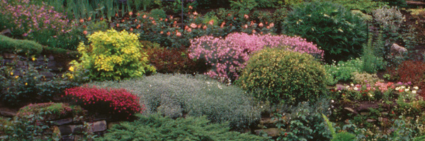
A wonderful English-style park houses more than 3000 species and varieties of trees and native and exotic flowers grouped into gardens. (200, Route 132).
Matane
630 km – 132 Est
The fishing port of 15,000 inhabitants is known for its shrimp. At the Mathieu-d’Amours (260, Saint-Jérôme Avenue) dam, discover the Atlantic salmon and watch their migration. Near the City Hall, a walkway leads to the Parcs des Iles (beach, paddle boats, picnic tables).
Sainte Anne des Monts
720 km – 132 Est
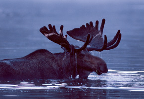
Discover the Parc National de la Gaspésie (1981, route du Parc). In the heart of the peninsula, the monts Chics-Chocs allow you to observe moose and caribous. Several picnic areas are available.
Gaspé
915 km – 132 Est
The name means « Lands End ». The French adventure in North America began in Gaspé. The city has 17 coastal villages. The Gaspé Bay is the summer event for swimmers, yachtsmen and sportsmen.
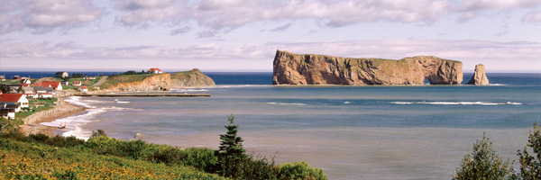
Percé
986 km – 132 Est
The Baie de Percé Bay reveals a unique landscape. The Parc de l’île Bonaventure and Rocher Percé (4 rue du Quai) can be reached on foot at low tide. Huge barrier of limestone, the Rocher is equipped with a natural arch of 20 meters high. The island is a protected nest for thousand of seabirds that come to mate.
Bonaventure
1170 km – 132 Ouest
The village is crossed by the Bonaventure River known for its water filled with of salmon.
The musée Acadien (95 avenue du Port-Royal) traces the history of the Acadian deportation in 1755 and who settled several regions of Quebec.
the Bioparc (123, rue des Vieux-Ponts) presents the fauna and flora of the Gaspé ecosystems.
Carleton-sur-Mer
1230 km – 132 Ouest
This resort has beautiful beaches. From Mont-Saint-Joseph, discover the coastal and sandy views where the boats fail.
Ristigouche
1300 km – 132 Ouest
The Micmac Indians of the reserve have raised strong within which the customs are present. We offer to sleep in the tent, listening to legends and enjoy traditional dishes.